
Welcome to my mountain world. For over half a century, I have walked the ridges and canyons of the Dinaric Alps, documenting the ‘Mountain Eyes'—the fragile glacial lakes that represent the soul of Bosnia and Herzegovina. This article is the result of fifty years of professional guiding and research. It is more than just a list. It is my personal record of a vanishing wilderness.
I invite you to study these waters, respect their history, and understand the threats they face. The mountains are not in a hurry, and I hope you will take your time to read their story.
Author of text and photography: Braco Babić
🗺️ Coverage: Over 40 lakes across Zelengora, Treskavica, Prenj, and more.
⚠️ Safety: Critical warnings for hikers on Mt. Treskavica.
🧬 Endemics: Where to find the prehistoric Alpine Triton.
🏔️ The Highest Point: A guide to Crvenak Lake (1970 m a.s.l.).
Jump to a Mountain Range: Zelengora | Čvrsnica | Prenj | Šator Mountain | Crvanj | Lebršnik | Treskavica | Bjelašnica | Raduša | Visočica | Vranica
The mountain lakes of Bosnia and Herzegovina are situated in the central part of the Dinaric mountain region. From the southeast to the northwest of the Dinaric Mountains, the mountain ridges of Lebršnik, Zelengora, Lelija, Crvanj, Treskavica, Bjelašnica, Prenj, Čvrsnica, Vran, Vranica, Raduša, Cincar, Troglav, and Šator follow one after another. Within this zone, we encounter a large number of mountain lakes which, unfortunately, find themselves in their final evolutionary stage of development; some of them have, for a long time now, taken on the characteristics of marshes or ponds. Some of these lakes can be reached by car, and there is a rightful fear regarding the increasing endangerment and disappearance of these beautiful “mountain eyes” that decorate our mountain wilderness with their crystal-clear waters.
Almost all mountain lakes in Bosnia and Herzegovina are younger hydrographic formations. Through the processes of washing away and the deposition of rock decay products, the lake basins are being intensely filled. If the necessary restoration and protective works are not carried out within the lake watersheds—under mandatory scientific and professional supervision—the mountain lakes of Bosnia and Herzegovina will disappear relatively quickly.
Beyond natural negative processes, their disappearance is continuously accelerated by other negative influences: the pollution of lake water and the surrounding environment, artificial interventions, the devastation of lake watersheds, fish stocking, the construction of weekend dwellings and even entire holiday settlements, auto-camps, and similar developments (as seen, for example, with Prokoško and Boračko lakes).
Some lakes, although they bear such a name, actually correspond more to ponds, puddles, or marshes than to a lake, considering their hydrographic and morphographic character. This writing provides a brief overview of mountain lakes regardless of their origin, size, or character. Given their negligible surface area and volume, the mountain lakes of Bosnia and Herzegovina have no economic significance. Some of them serve tourist functions, while the majority serve as watering holes for the livestock of nomadic herders.
In existing geographical and other literature, the opinions accepted until recently were that almost all mountain lakes were formed in morphological depressions and date back to the Pleistocene period, when some of our Dinaric mountains were affected by glaciation. Because of this, even today, all mountain lakes and some other natural lakes in Bosnia and Herzegovina are—often without supporting evidence—referred to as “glacier or glacial lakes.” You can learn more about this and many other interesting facts in the book NATURAL LAKES OF BOSNIA AND HERZEGOVINA, a limnological monograph, by Prof. Dr. Muriz I. Spahić (HARFO-GRAF, Tuzla, 2001).
LAKES ON ZELENGORA
The largest number of mountain lakes can be found on Mount Zelengora, as well as on Treskavica. There are a total of 10 lakes on Zelengora, 8 of which are of glacial origin. They are fed by glaciers, sub-lacustrine (under-lake) springs, surrounding springs, and streams. All lakes are accessible via hiking trails—some of which are officially marked—while others can be reached relatively closely by car. Except for Bijelo Jezero and Gornje Bare, fish can be found in all the other lakes. The first fish stocking was carried out by the Fisheries Institute of Bosnia and Herzegovina in 1963. Five lakes are located within the “Sutjeska” National Park: Crno, Bijelo, Donje Bare, Gornje Bare, and Orlovačko. Located outside the park boundaries are: Kladopoljsko, Štirinsko, Kotlaničko, Borilovaćko, and the lake under Pliješ peak.
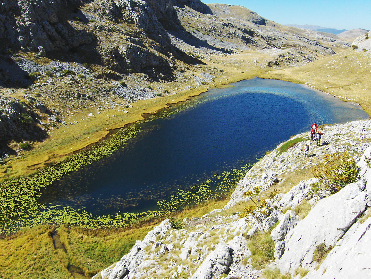
Kladopoljsko jezero / Kladopoljsko Lake (1350 m a.s.l.): Is located on the western slopes of Mount Zelengora. The lake lies in a canyon near Kladovo Polje, squeezed between the steep cliffs of Muravske Strane and Planinica. It is overgrown on all sides with lush sedge and other marsh plants, notably the yellow water lily. Wooden logs (klade) lie at the bottom of the lake. There is no forest vegetation anywhere around the lake or in the field, which suggests that in the past, there were large forest complexes here or that a road for transporting logs passed by the lake. The lake and the field were named after these logs. The lake is 250 m long, 100 m wide, and up to 9 m deep. The only fish species in the lake is brown trout. The lake can be reached closely by off-road vehicle from the direction of Kalinovik via the villages of Oblje, Suho Polje, and Kladovo Polje. From Oblje, the lake can be accessed by a marked hiking trail (2 hours walk).
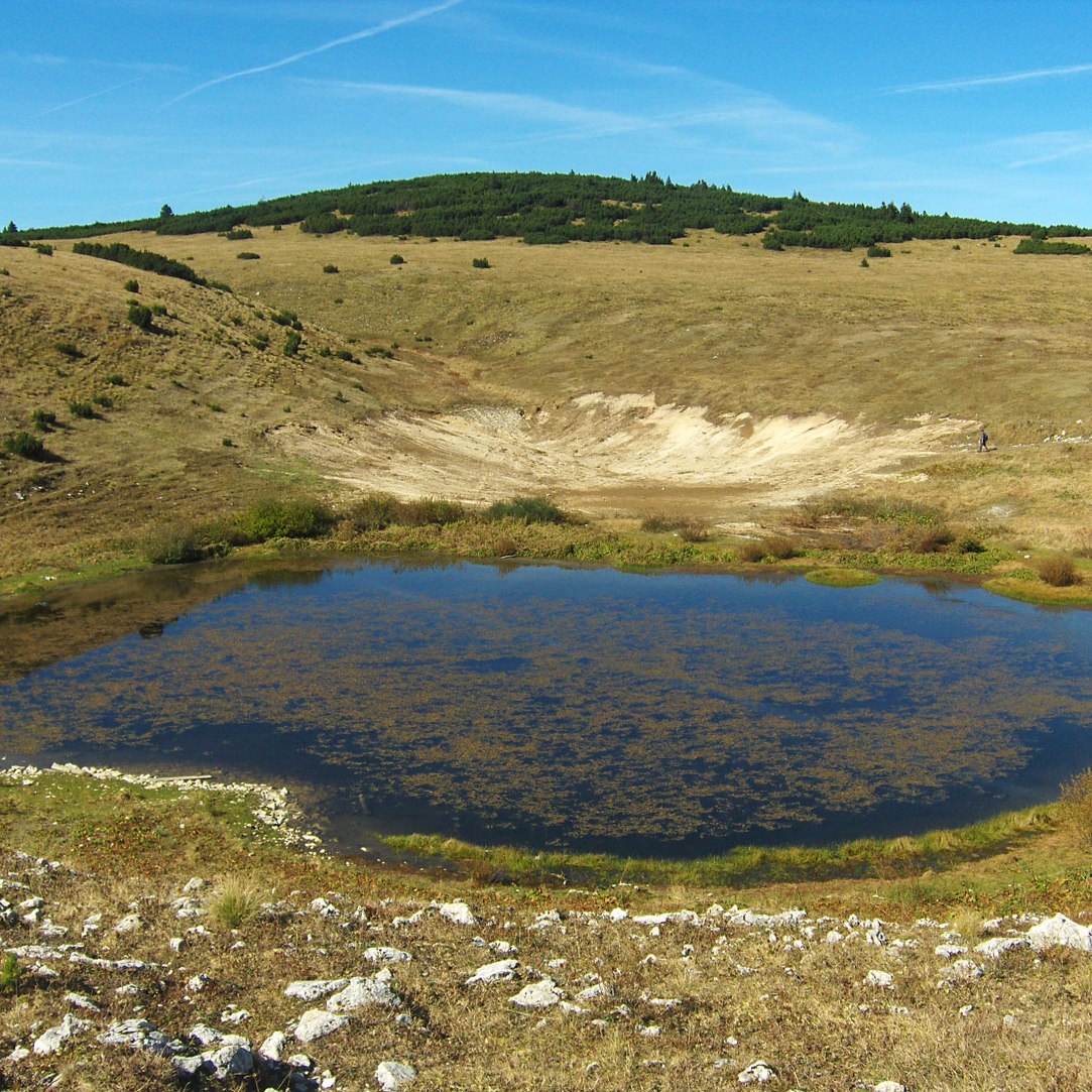
Štirinsko jezero / Štirinsko Lake (1672 m a.s.l.): Is located on the northern side of the Mali Zimomor peak. The lake lies on the vast Štirine plateau, after which it was named. Around the lake are extraordinary mountain landscapes: meadows covered with green grass, interspersed with diverse mountain flowers and white limestone surfaces. Of all the lakes on Zelengora, it is located at the highest altitude and has the largest surface area. The lake is 600 m long, 300 m wide, and up to 4.5 m deep. The Arctic char inhabits it. Along with Kotlaničko and Bijelo, it is one of the three Zelengora lakes that cannot be closely approached by car. The lake can be accessed by a marked hiking trail from two directions: from the hunting lodge on Borilovac and from the pass on Borovno Brdo (2 hours walk).
Kotlaničko jezero / Kotlaničko Lake (1528 m a.s.l.): Lies in a karst depression squeezed by the bare rocky peaks of Prutača, Kotura, Dumoš, and Veliki Zimomor. The triton, an endemic amphibian, lives in the lake. It is the deepest on Zelengora, 480 m long, 200 m wide, and up to 10 m deep. The lake is rich in fish (Arctic char). The lake can be approached from the pass on Borovno Brdo via a marked hiking trail (2 hours walk).
Orlovačko jezero / Eagle Lake (1438 m a.s.l.): Is one of the most beautiful mountain lakes in Bosnia and Herzegovina. It is located in the central part of Zelengora and is surrounded by the peaks: Orlovac, Ljeljen, and Stog. It is closed off by high ridges, partially surrounded by beech forest and lush pastures. It is kidney-shaped, 380 m long, 100 m wide, and up to 5 m deep. The bottom of the lake is overgrown with sedge and green grass, which is why the water looks blue-green. The shores are sandy and easily accessible. Around the lake are pastures full of flowers, and above are gray limestone peaks interspersed with green dwarf pine and snowfields. The lake can be reached by off-road vehicle from two directions: from Kalinovik via Konjska Voda and from Čemerno via the pass on Borovno Brdo.
Crno jezero / Black Lake (1440 m a.s.l.): Lies in a deep forest on the northeastern side of the Orlovac peak. It is oval-shaped, 170 m long, 80 m wide, and up to 3 m deep. The bottom of the lake is covered with grass, and the surroundings with high coniferous forest; as a result, the water looks black, giving the lake its name. Due to the environment in which it is located, it is among our most beautiful mountain lakes. The lake can be reached closely by off-road vehicle from the direction of Tjentište via Štavanj and Vrbnica to Srijemušna Luka. Further to the lake is a 30-minute walk.
Bijelo jezero / White Lake (1416 m a.s.l.): Lies on the northern side of the Orlovača peak. Fine white sand is found at the bottom of the lake, after which it was named. It is also known as Zeleno (Green) Lake due to its color. It is the smallest in surface area, irregularly shaped, 90 m long, 70 m wide, and up to 2.5 m deep. It is indented in relief that could allow for larger accumulation, which would significantly increase the lake's surface. It is about a 30-minute walk from Crno Lake.
Jezero Gornje Bare / Lake Gornje Bare (1510 m a.s.l.): Lies on the northern side of the Tovarnica slopes, at the foot of the Dobra pass and Uglješin Peak. it is elliptical, 150 m long, 80 m wide, and up to 2 m deep. The bottom is muddy, sprinkled with sand, and overgrown with fine grass. Around the lake, the terrain is covered with high mountain grass interspersed with blueberry bushes. The lake can be reached closely by off-road vehicle from the direction of Tjentište via Krekovi and Careva Gora. Further to the lake is a 30-minute walk.
Jezero Donje Bare / Lake Donje Bare (1470 m a.s.l.): Lies on the eastern side of the Ardov peak. It is elliptical, 250 m long, 120 m wide, and up to 4.5 m deep. Beautiful meadows and forests around the lake create an Alpine atmosphere. A hunting lodge is located in the immediate vicinity. The lake can be reached by off-road vehicle from the direction of Tjentište via Krekovi and Careva Gora.
Borilovaćko jezero / Borilovaćko Lake (1480 m a.s.l.): Lies in the Borilovići area between two peaks: Kalelija and Stog. It is also called Jugovo Lake after the former gamekeeper of the Sutjeska National Park, Jusuf Jugo, who was its conceptual creator and builder. The lake was created by artificial damming (closing a sinkhole) to prevent water from flowing away. This marvelous work of human hands began construction in the middle of the last century. Over time, the lake has taken on the characteristics of a natural lake. It is circular, 250 m long, 100 m wide, and up to 4 m deep. It is surrounded by marsh moss and pond plants. Around the lake are vast pastures with succulent mountain grass. The lake can be reached by off-road vehicle from Kalinovik via Konjska Voda or from Čemerno via the Borovno Brdo pass.
Jezero pod vrhom Pliješ / Lake under the Pliješ peak (1140 m a.s.l.): Lies in a hollow near the crossroads for Palež and Pašina Poljana. It is fed by surrounding springs, melting snow, and rainwater. It is elliptical, 250 m long, 50 m wide, and up to 2 m deep. It is overgrown on all sides with marsh vegetation. The Oteša stream flows out of the lake and joins the Bistrica river near Miljevina. The lake can be reached by off-road vehicle from Miljevina via the village of Rataja.
LAKES ON ČVRSNICA
Jezero Crvenak / Lake Crvenak (1970 m a.s.l.): Is at the highest altitude and is the smallest glacial lake in Bosnia and Herzegovina by surface area. It is also known as Crljenak. It is located on the western side of the Trinača peak on the edge of the craggy Strmenica, near the famous Hajdučka Vrata (10 minutes walk). It is oval, 70 m long, 50 m wide, and up to 9 m deep. Around the lake, the terrain is covered with difficult-to-pass dwarf pine. The triton, an endemic amphibian, lives in the lake. It is one of our few mountain lakes whose water is drinkable. The most favorable access to the lake leads from the “Vilinac” mountain hut via a marked hiking trail (1 hour walk).
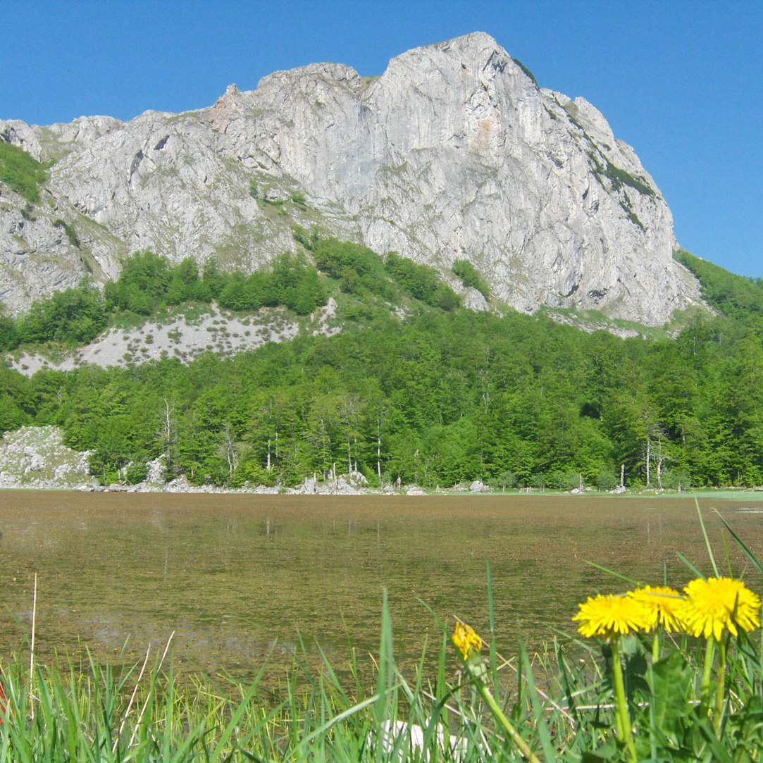
Blidinjsko jezero / Blidinjsko Lake (1183 m a.s.l.): Lies in Ivan Dolac at the very end of Dugo Polje, squeezed by the steep slopes of the Jelinka peak on Čvrsnica and Borova Glavica on Vran Mountain. The lake was created by artificial damming (closing sinkholes). Over time, it took on the characteristics of a natural lake. It is 2.5 km long, 1.5 km wide, and up to 2 m deep. By surface area, it is the largest mountain lake in Bosnia and Herzegovina. It is fed by melting snow and rainwater. In summer, a large part of the water disappears into sinkholes, causing the lake level to drop significantly. Numerous fish species are found in the lake: chub, Dalmatian barbel-gudgeon (oštrulja), podbila, and rainbow trout. Around the lake, the terrain is suitable for livestock grazing. The lake is protected under the “Blidinje” Nature Park. The best access by car is from Jablanica via Sovići Vrata.
Orlovo jezero / Eagle Lake (1800 m a.s.l.): Is located east of the ski center at Blidinje (about 2.5 km air distance). The lake lies in the area of Donji Mejdani in a hollow south of Orlov Kuk peak, after which it was named. It is of glacial origin. It is fed by glaciers and a nearby spring. The terrain around the lake is overgrown with dense dwarf pine. The lake is modest in size. Access is via a hiking trail from the funerary chapel at Risovac (3 hours walk).
Ledeno jezero / Ice Lake (1750 m a.s.l.): Is located in the Velika Čvrsnica massif. The lake lies in an amphitheater under the impressive Pesti Brdo / Ploča peak. It is of glacial origin. The environment in which the lake is located represents a real small oasis. It is fed by glaciers and a nearby spring. The lake is of modest dimensions. Access is from the “Vilinac” mountain hut (3 hours walk).
LAKES ON PRENJ
Boračko jezero / Boračko Lake (404 m a.s.l.): Is located on the northeastern side of Prenj between Crna Gora and Tranjina. It represents one of the largest natural lakes in Bosnia and Herzegovina. It is situated in a large hollow at the extreme southeastern part of Boračka Draga, near the regional road Konjic – Glavatičevo. The lake is surrounded by coniferous and deciduous forests. It is of glacial origin, elliptical in shape, 780 m long, 400 m wide, and up to 14 m deep. The shore is overgrown with reeds, water lilies, and other marsh plants where wild ducks, coots, and grebes nest. It receives water from the Borački stream and the stream of Boračka Draga, as well as several strong springs. The Šištica river flows out of the lake, about 3 km long, and flows into the Neretva (left tributary). At the mouth, the water sinks and breaks through the rocks with a loud sound resembling hissing (“šištanje”), ending in the Neretva with a 30 m high waterfall. It is a paradise for fishermen (carp, brown, lake, and rainbow trout, and river crayfish). Due to heavy construction and negative human impact, it is one of our most endangered mountain lakes. It can be reached by car from Konjic (21 km). It was placed under state protection in 1954 and is on the IBA (Important Bird Areas) list.
Jezerce / Lake (1655 m a.s.l.): Is located in the central part of Prenj. The lake lies in a hollow on the southern side of the striking Taraš peak. It is of glacial origin, fed by glaciers and a nearby spring. In summer, a herd of horses often stays around the lake, a pastoral image worth seeing. A beautiful atmosphere is created when the Osobac peak is reflected on the surface. It is of modest dimensions. Nearby is the mountain hut of the same name (10 minutes walk). Access is from the Konjička Bijela valley via Skok (3 hours walk).
LAKE ON ŠATOR MOUNTAIN
Šatorsko jezero / Šatorsko Lake (1488 m a.s.l.): Is located in the central part of Šator Mountain. The lake lies in a vast hollow on the northern side of Veliki Šator, the highest peak of the mountain. It is of glacial origin, elliptical, 280 m long, 150 m wide, and up to 8 m deep. It is fed by glaciers and sub-lake springs. It is a sanctuary for the Alpine Triton, an endemic amphibian. The Mlinski stream flows out of the lake and, together with the Šatorski stream, forms the Unac river. Nearby is Bulino Vrelo, which according to folk legend heals all diseases. Traditionally, people gather at the lake on St. Elijah’s Day (August 2). Accessible by off-road vehicle from Bosansko Grahovo via Tičevo or from Livno via Gornji Peulji.
LAKE ON CRVANJ
Crvanjsko jezero / Crvanjsko Lake (1050 m a.s.l.): Is located on the eastern slopes of Mount Crvanj. It is also known as Bačko. It is surrounded by Mali Vrh hill and a belt of beech forest. It is of glacial origin, kidney-shaped, 500 m long, 270 m wide, and up to 13 m deep. It is fed by glaciers, sub-lake, and surrounding springs. The Jezerac stream flows out and joins the Gvozdnica stream to flow into the Neretva. The lake is stocked with carp and lake trout. Regressive erosion of the Jezerac stream is causing the lake to lose more water, and the lake has long since entered its final evolutionary phase. Nearby is the village of Jezero, accessible by off-road vehicle from Ulog (12 km).
LAKES ON LEBRŠNIK
Jezero pod vrhom Kuk / Lake under the Kuk peak (1501 m a.s.l.): Lies in a hollow surrounded by the rocky cliffs of Kuk, Lupoglav, Krvavica, and Košara. It is of glacial origin and belongs to the source headwaters of the Sutjeska river. It is 50 m long, 25 m wide, and up to 2 m deep. It is seasonal and dries up in summer. Nearby is a mountain hut in Papin Do, accessible by off-road vehicle from the Čemerno pass (8 km). Further to the lake is a 30-minute walk.
Jagodino jezero / Jagodino Lake (1507 m a.s.l.): Lies in a wide hollow surrounded by Jagodina Glavica and the Košara peak. It is of glacial origin, 60 m long, 40 m wide, and 2 m deep. It is seasonal and has dried up during the summer in recent years. Access is the same as for the lake under Kuk.
Jezero pod Ravnom Gredom / Lake under Ravna Greda (1400 m a.s.l.): Is also known as Jezerina. It is of glacial origin, 100 m long, 30 m wide, and up to 2 m deep. It is seasonal. Access is from Čemerno to the mountain hut (Inića Grob), then a 40-minute walk.
Jezero u Čemernom / Lake at Čemerno (1288 m a.s.l.): Lies in a hollow to the right of the road towards the source of the Sutjeska. It is of modest dimensions, seasonal, and fed by melting snow and rain. Accessible by off-road vehicle (1 km from the pass).
Škipina lokva / Škipina Puddle (1647 m a.s.l.): Lies on a wide plateau near Provaljeni Do. It is seasonal and modest in size. Accessible from Papin Do (2 hours walk).
LAKES ON TRESKAVICA
Treskavica is home to a vast number of lakes, renowned for the exceptional beauty of the landscapes in which they are nestled. They are fed by glaciers, sub-lake springs, surrounding springs, and mountain streams. The Veliko, Platno, Crno, and Bijelo lakes are of glacial origin and have been officially declared protected monuments of nature.
Note: During the past war (1992–1995), heavy battles were fought on Treskavica, leaving behind unexploded ordnance and anti-personnel mines. For this reason, it is strictly recommended that you do not move off the marked hiking trails. The areas around the lakes at Spasovača, Gornja Bara, and Simovića Bara are particularly high-risk.
Veliko jezero / Great Lake (1550 m a.s.l.): Located in the central part of Treskavica, this lake lies in a vast hollow between the Ljeljen peak to the west and the Nikoline Stijene cliffs to the east. It is glacial in origin, fed by glaciers and surrounding springs. It also receives water from Platno Lake via a stream. Due to the constant infilling by scree and alluvial deposits, the lake's dimensions are slowly shrinking. It is 290 m long, 150 m wide, and up to 5 m deep. The water flows out on the eastern side and sinks beneath the moraine barrier at Šišan, continuing as the Glibovac stream until it reaches the Skakavac waterfall, after which it changes its name to Hrasnica. Its eastern shores are thick with marsh vegetation, and the lake is stocked with rainbow trout. Access: Marked hiking trail from the village of Turovi (2.5 hours walk).
Platno jezero / Cloth Lake (1580 m a.s.l.): Located only about 150 m southeast of Veliko jezero, locals also call it Blatno Jezero (Muddy Lake). It sits at the bottom of the Krajačić canyon, squeezed between Nikoline Stijene and the Buca Glava peak. It is fed by the glaciers of Nikolino Ždrijelo and underground springs. The lake is 80 m long, 30 m wide, and up to 2 m deep. Its bottom is covered with silt and white mud. Access: Marked hiking trail from Turovi (3 hours walk).
Crno jezero / Black Lake (1675 m a.s.l.): Northwest of the Great Lake, Crno Jezero lies in a hollow between Ljeljen and Ilijaš. In summer, its shores are a favorite spot for swimming and camping. The lake is 170 m long, 100 m wide, and up to 4 m deep. Is home to the Triton, an endemic amphibian. Access: Marked hiking trail from Turovi (3.5 hours walk).
Bijelo jezero / White Lake (1697 m a.s.l.): Located northeast of Treskavica’s highest peak, Ćaba, this lake sits at the foot of the Ćabenske Stijene cliffs. It is under constant threat of disappearing as scree from the cliffs above intensely fills its basin. It is 140 m long, 80 m wide, and up to 1 m deep. Snow and ice linger here for much of the year, which is how it earned its name “White Lake”. Access: Marked hiking trail from Turovi (4 hours walk).
Zmijsko jezero / Snake Lake (1633 m a.s.l.): Found east of the Oblik peak, this lake lies in a hollow beneath the rocky ridge connecting the summits of Oblik and Zubovi. Above the lake runs a craggy footpath leading from Turovo Stan to Ovčije Ždrijelo. It holds water year-round. Access: Marked hiking trail from Turovi (3 hours walk).
Jezero na Turovom Stanu / Lake on Turov Stan (1640 m a.s.l.): This lake is hidden, surrounded on all sides by dense beech forest near a former hunting lodge. Fed by melting snow and rain, it holds water all year and is known as a vital watering hole for wild beasts and other mountain game. Access: Marked hiking trail from Turovi (3 hours walk).
Trokunsko jezero / Trokunsko Lake (1220 m a.s.l.): Also known as Suho Jezero (Dry Lake), it lies in a deep hollow under the rugged cliffs of Mali Čardak. It is a stark example of negative geographica l processes; the lake is almost entirely buried by rock fragments and trees brought down by avalanches, causing it to dry up and nearly vanish. Access: Footpath from the village of Dujmovići (1 hour walk).
Jezero na Spasovači / Lake on Spasovača (1590 m a.s.l.): Located in a shallow hollow beneath the Vjetrene Stijene (Windy Cliffs) and surrounded by beech forest and mountain pastures. It is seasonal and dries up in the summer.
Warning: The terrain immediately surrounding the lake is a high-risk area for landmines from the past war.
Jezero na Gornjoj Bari / Lake on Gornja Bara (1600 m a.s.l.): This lake lies in a large hollow where a great katun (shepherd's settlement) once stood. In its immediate vicinity is a medieval necropolis with Stećci (tombstones). It is seasonal and modest in size.
Warning: The terrain immediately surrounding the lake is a high-risk area for landmines from the past war.
Jezero Simovića Bara / Lake Simovića Bara (1395 m a.s.l.): Also known as Gospina Lokva (The Lady’s Puddle) or Gvozno jezero, it lies in a deep hollow beneath the rocky cliffs of Veliki Treskač and Mali Treskač. Though created by human hands (by closing a sinkhole), it has long since taken on the character of a natural lake. It is 200 m long, 100 m wide, and up to 4 m deep. Rich in rainbow trout, attracting passionate fishermen.
Warning: The terrain immediately surrounding the lake is a high-risk area for landmines from the past war.
LAKES ON BJELAŠNICA
Lokvanjsko jezero / Lokvanjsko Lake (1760 m a.s.l.): Located on the northeastern side of Mount Bjelašnica, this lake lies in a hollow on the western side of the Mala Vlahinja Peak. It is of glacial origin and elliptical in shape, measuring 100 m long, 60 m wide, and up to 2 m deep. It is fed by glaciers and a nearby spring. The lake is home to the Alpine Triton, an endemic amphibian. It is currently exposed to heavy infilling by scree (rock fragments) from the eastern side, where a marsh has begun to form. Half of the lake's surface is already covered by marsh vegetation, with a tendency to spread further. If urgent restoration is not carried out, the lake faces total disappearance. Access: Follow the marked hiking trail from the “Mrtvanjski Stanari” mountain hut (1.5 hours walk).
Blatačko jezero / Blatačko Lake (1150 m a.s.l.): Situated on the southwestern part of Bjelašnica, this lake lies in a karst hollow near the village of Blace, after which it was named. It is glacial in origin, oval-shaped, 420 m long, 175 m wide, and up to 2 m deep. It is fed by sub-lake springs. Due to its use as the primary watering hole for livestock, a process of marsh vegetation growth has begun. The lake has taken on a swampy appearance, and only one-third of its surface remains free of vegetation. For a long time now, by scientific definition, it has effectively ceased to be a lake. Access: Accessible by off-road vehicle from Konjic via the villages of Džepi and Vrdolje.
Kalajli jezero / Kalajli Lake (1645 m a.s.l.): Located on the northwestern slopes of Bjelašnica, this lake lies within one of the many sinkholes in the area between the Opančak katun (shepherd settlement) and the Hranisava peak. It is of modest dimensions and glacial origin, fed by glaciers and sub-lake springs. It holds water throughout the entire year. Access: Reachable by off-road vehicle from Tarčin to the Opančak katun, then continue along a shepherd's path to the lake (1 hour walk).
Sitničko jezero / Sitničko Lake (1695 m a.s.l.): Found in the central massif of Bjelašnica, this lake lies in a large valley near the “Sitnik” mountain hut. It is of modest dimensions. The lake was created artificially in the middle of the last century by damming and sealing the bottom to prevent water drainage. it plays an important role as a watering hole for livestock. It is fed by melting snow and rain; it is seasonal and dries up during the summer.
Balića jezero / Balića Lake (1370 m a.s.l.): Located in the central massif of Bjelašnica, this lake lies in a valley near the village of Umoljani, specifically near the hamlet of Elezovići. It is modest in size and fed by two surrounding springs, melting snow, and rainwater. It is seasonal and dries up in the summer, serving primarily as a watering hole for livestock. Access: Accessible via a shepherd's path from Umoljani or Elezovići (30 minutes walk).
LAKES ON RADUŠA
Veliko ili Rumbočko jezero / Great or Rumbočko Lake(1830 m a.s.l.): Located in the central massif of Mount Raduša, on the northeastern side of Idovac, the mountain's highest peak. It is circular, 85 m long, 70 m wide, and up to 1.5 m deep. The lake has no constant tributaries or outflows and is fed solely by melting snow and rain. It is being intensely filled by alluvial deposits from the north and northwest. Today, the lake is almost entirely covered by marsh vegetation and is at high risk of vanishing.
Warning: The terrain immediately surrounding the lake is a high-risk area for landmines from the past war.
Malo ili Voljičko jezero / Small or Voljičko Lake(1730 m a.s.l.): Also located in the central massif on the Plandište plateau. This modest lake is similarly threatened by encroaching vegetation and the risk of drying out completely.
LAKES ON VISOČICA
On the northeastern slopes of Mount Visočica, there are several small lakes. These lakes are situated in depressions at altitudes ranging from 1300 – 1650 m. They are fed by snowmelt and rainwater. Being seasonal in nature, they tend to dry up during the summer months. Generally, they have the characteristics of large ponds and primarily serve as watering holes for livestock.
Among the most notable are: Veliko Jezero (Great Lake) below the Vito peak, Srednje Jezero (Middle Lake) and Malo Jezero (Small Lake) below the Subar peak, Kolovetnice Lake below the Drstva peak, the lake below Mokre Stijene, and the lake in the Jelenača Valley. These lakes can be reached via marked hiking trails from the Tušila Valley, where the “Vrela” mountain hut is located near the village of Sinanovići.
Kolečića Bara (1650 m a.s.l.): Located in the central massif of Visočica, on a vast plateau so rich in springs and streams that the entire area is simply named Jezera (The Lakes). It is interesting to note that twenty years ago, all the lakes on Visočica held water throughout the entire summer, providing vital resources for the nomadic herders for which Visočica was a famous center. Today, they have become seasonal and dry up in the heat. Access: By off-road vehicle from Sinanovići (Tušila) or the village of Luka (Bjelimići). Both routes lead to the “Police” and “Poljice” plateaus, both of which feature magnificent medieval necropolises with Stećci (tombstones) near the water.
LAKE ON VRANICA
Prokoško jezero / Prokoško Lake (1636 m a.s.l.): Situated in the central massif of Mount Vranica, this lake lies in a wide basin surrounded by peaks rising over 2000 m. It is one of the largest and most breathtaking mountain lakes in Bosnia and Herzegovina. Glacial in origin and oval-shaped, it is 430 m long, 190 wide, and up to 13 m deep. It is a sanctuary for the Alpine Triton, an endemic amphibian and the rare Bosnian Orchid (Orchis bosniaca).
The lake is a declared Monument of Nature, yet it remains one of our most endangered. The “fever” of construction over the last decade—hundreds of shepherd huts and weekend cottages—along with the devastation of the southwestern slopes has severely damaged the ecosystem. One-third of the lake is already heavily silted and marshy. Furthermore, the construction of a forest road has interfered with the lake's natural outflow, causing regressive erosion that drains the lake's volume.
On the southeastern shore, surrounded by rare spruce forests and dwarf pine, a new mountain hut is being built on the foundations of the old one that burned down in 1983. Access: Off-road vehicle from Fojnica via Jezernica.
Prokoško jezero Prokoško Lake is protected by law as a Monument of Nature of Bosnia and Herzegovina.

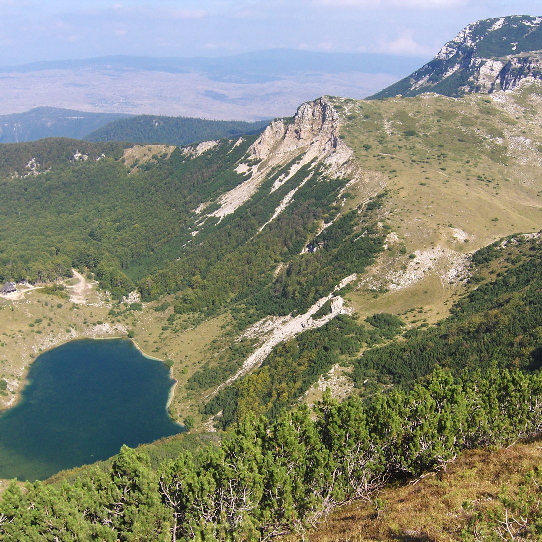


Cover image: Zelengora, Kladopoljsko jezero / Kladopoljsko Lake (1350 m a.s.l.)
Join the conversation
I would like to hear from you. Whether you are an experienced mountaineer, a traveler planning a first visit to our peaks, or someone who simply appreciates the raw beauty of nature—your thoughts are welcome.
Have you stood on the shores of these lakes? Do you have questions about the technical data or the safety of the trails I have described? Please, leave a comment or ask a question below. It is my pleasure to share this knowledge with you.

